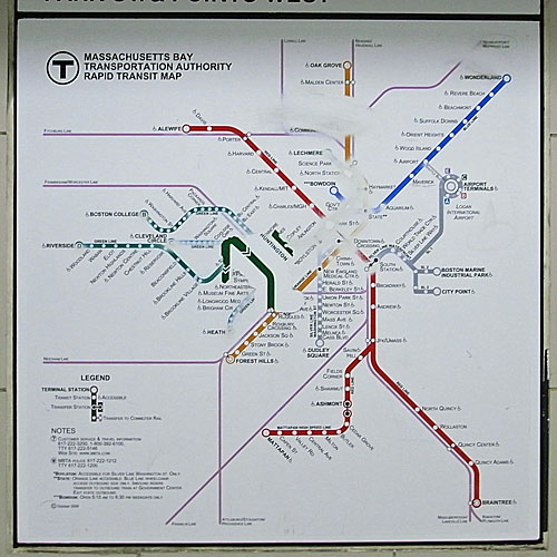
I was excited to hear that Google maps had finally added Boston’s public transit system. Now you can get directions around Boston for driving, walking, and public transit. Of course, the MBTA website has been providing a trip planning service for some time. So I figured I would compare the two services recommendations. Too lazy to do anything particularly scientific, I asked both to tell me how to get from limeduck world headquarters (a secure undisclosed location in Central Square) to Modern Pastry in the North End at 8:30pm tomorrow. The variance is shocking.

The defending champ, the MBTA Trip planner coughed up two suggestions:
- Red line to Orange line to Haymarket in 23 minutes
- Red line to Green line to Haymarket in 28 minutes
This pretty conclusively reinforced my preference for the Orange line to the Green, even if it means an extra stop on the Red.
The contender, Google Maps, brought four different routes, although two of them are essentially identical.
- Red line to Green line to Haymarket in 19 minutes
- Red line to Downtown Crossing, then walk the rest of the way in 22 minutes (duplicated with different Red line departures)
- Red line to Green E line (at Symphony) to Haymarket in 37 minutes
Both sets of times include the walking time on each end. I don’t know which of these plans is more accurate. I have to believe that the MBTA should know the schedule better, but I also believe that Google might be reporting more realistic data. Both systems agree that the Red line departing Central at 8:33 will arrive at Park Street at 8:39, but it all goes haywire after that, with a whopping nine minute difference in estimating the same trip, with Google saying it’s quicker to hoof it than to take either of MBTA’s Green or Orange legs.
I checked, the Orange line does show up in some Google routes at different times, but it looks like it doesn’t arrive very often, which might skew things. Google’s last suggestion is so off the wall that it makes me doubt the whole system – take the #1 bus down Mass ave past the B C & D Green line station at Hynes and the Orange line station at Mass Ave to get on the E branch of the Green line at Symphony?? Feh.
Poor Google, has Boston’s beany maze bested your mapping mojo?

FYI: The last trip returned by Google is the diversity trip — it tries to find a trip that doesn’t use the vehicle types listed on the previous trips (here for instance, it avoids subways).
Thanks for the tip! The Diversity Trip – I like the sound of that. I’m not sure I like the route, but I like the idea. More geek points for Google, but I think their coding of the different types of MBTA routes might be a little off. The Green line goes underground downtown so the distinction is not that useful on this particular trip example.
In NYC, I’m all about Lord Google’s transit directions. In Boston… well, after a few tries using their driving directions I started polling my friends to see if they thought Google knew it’s way around Boston, with the results being not so favorable. So I’m not surprised to hear that their MBTA directions might be weak.
Hey David. Thanks for the post and glad I found you. I’ve been waiting for GOOG to clue into the MBTA after focusing their public transit coverage mostly on cities without and public transit. Do you know of any GOOG Map ups of the proposed Green Line Extension, by any chance?
Paul (bloggingbelmont.com)